The Grey Zone: a doctrinal clarification for frontline mapping
Cartography and storytelling

There remains a great deal of confusion surrounding the notion of the grey zone in frontline mapping, and this confusion continues to produce systematic misinterpretations among mappers and analysts. In most cases, the disagreement is not about facts on the ground, but about the misuse of doctrinal concepts.
The grey zone is a construct, defined not by exposure to drones or artillery but by the fact that neither side can deny the other the ability to operate on the ground.
Grey zone versus no man’s land
First and foremost, the grey zone must not be confused with no man’s land. A no man’s land is, by definition, an unmanned area separating enemy positions. The grey zone, by contrast, refers to an area in which both sides are able to operate at the same time. This distinction is fundamental and is often overlooked.
Grey zones, an abstract concept derived from “contested ground”, tend to emerge in terrain that makes exclusive control difficult. Urban areas, villages, forests, hills, and rocky or compartmented ground allow small units from both sides to move, hide, and conduct limited operations without immediately denying the adversary access. In such environments, presence is overlapping rather than sequential.
Doctrinal definition of control
To understand where the grey zone applies, it is first necessary to define control in doctrinal terms. U.S. Army doctrine defines control as “a tactical mission task that requires the commander to maintain physical influence over a specified area to prevent its use by an enemy or to create conditions necessary for successful friendly operations” (FM 3-90-1). Control is therefore not an abstract notion, nor a measure of comfort or stability, but a function of physical influence exercised on the ground, often confused with “Secure”:
Control of an area does not require the complete clearance of all enemy soldiers from the specified area. The tactical mission task of control differs from that of secure because secure does not allow enemy fires to impact on the secured area. The enemy can engage targets within the controlled area but cannot move ground forces through that area
This definition from tactical mission task manual is closely linked to the concepts of the forward line of own troops (FLOT) and the line of contact, both of which identify, through slightly different lenses, the boundary separating friendly and enemy forces at a given moment, which is not necessarily contiguous. The FLOT, in particular, “indicates the most forward positions of friendly forces in any kind of military operation at a specific time” and explicitly excludes small, long-range reconnaissance elements or similar stay-behind forces (FM 3-90-1).
What control actually implies
Control is thus about the ability to deny the enemy the use of an area without meaningful challenge, while a secured area at the rear is outside of enemy weapons range, except in modern times, long range assets. It implies that friendly forces can operate there routinely, while the enemy cannot do more than conduct sporadic long-range fires or isolated, temporary incursions.
The mere possibility that enemy personnel once passed through without operating meaningfully, or could theoretically strike from afar, does not negate control.
This doctrinal framing clarifies a common misconception: vulnerability does not equal lack of control. The ability of enemy drones to strike a position does not turn that position into a grey zone. One can be targeted by artillery 10km behind the line of contact without reclassifying the entire rear area as contested. The same logic applies to drones.
Practical implications for mapping
These distinctions have direct implications for mapping. In a village, once soldiers raise a flag and no credible information of enemy operational presence emerges, it can be a legitimate mapping criteria for control, up to the point reached. This remains true even if the position is tactically fragile, exposed to fires, or difficult to supply. The tactical objective of taking control has been achieved, even if it can be later reversed by enemy action.
The misuse of “consolidation”
The term “consolidation” is another frequent source of confusion (See the distinction with “Secure” above). Consolidation has no direct influence on control. Whether supply routes are easy or contested, whether a position is comfortable or precarious, does not alter the status of control.
If additional nuance is required, concepts such as limited or unstable control can be used, but the area remains controlled nonetheless. Consolidation is mostly about preparing a captured position against enemy counter attacks and reorganizing the attacking units toward the next objective, and therefore occurs after control is established.
Mapping reflects time, space, intent - storytelling
Another aspect often overlooked is that mapping is inherently also a function of both time and intent. A map is not a neutral object; it tells a story. Depending on what the map aims to convey, the criteria used to depict control may legitimately differ, and the visual elements applied to cartography adapted.
If the objective is to represent tactical dynamics with high temporal resolution: how often objectives change hands, the pace of counterattacks, then it is coherent to assign control as soon as it is demonstrated on the ground and to revise it when new geolocated evidence shows a reversal. If, instead, the intent is to present a clear and stable line of contact at a given moment, then a more conservative approach is justified, delaying changes until uncertainty has largely dissipated. Neither approach alters the doctrinal definition of the grey zone.
Let us apply those rules to a recently much debated situation: the village of Ternuvate in the Zaporijia direction, depicted in the maps below. Geolocated footage emerged in January showing Russian soldiers raising flags at multiple locations in the village, as well as in Kosivtseve to the south and further behind the Haichur river toward Huliailpole.
A doctrinal depiction would therefore show the village itself as a grey zone, since Ukrainian positions may still contest freedom of operations there. By contrast, the fields south up to the previous Russian FLOT should be marked as "controlled”, since no Ukranian positions capable to deny movement remained in this open areas, enabling forward assault groups to advance.
As per the purple area, it should be marked as a no man’s land, as the AFU abandoned positions east of the river long ago, precisely for this purpose: creating an empty pocket in the open fields, mined, with sensors, designed to detect any advance and target it rapidly with drone and artillery fire. This interpretation is consistent with the artillery strikes visible in the area on Clement Molin’s (@clement_molin) map (map 2), and with videos of Russian units seen progressing through it.
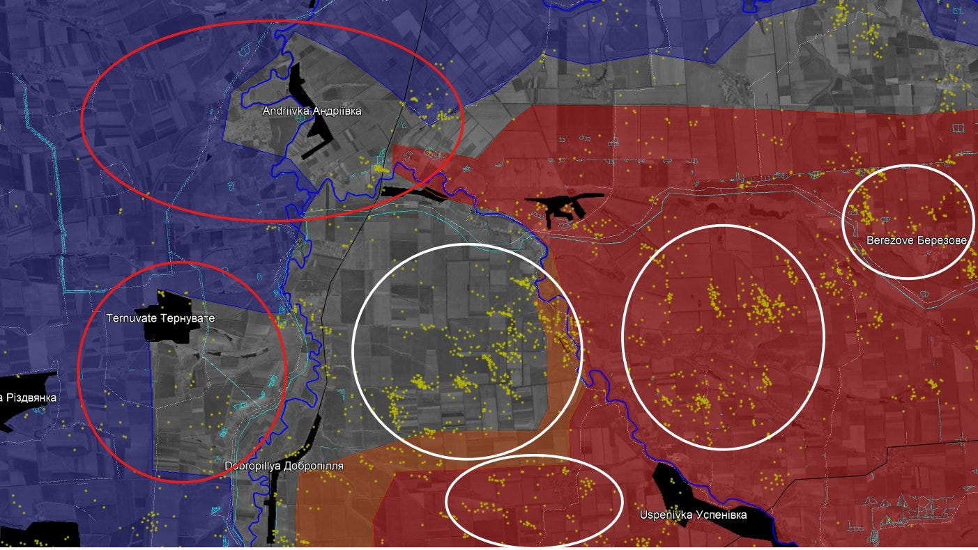
It is also important to point out that soldiers raising flags are not DRG (Deep Reconnaissance Groups), but forward assault groups. By definition, DRG do not reveal their positions to raise flags; but operate way behind enemy lines, for sabotage, targeting or mapping of enemy positions. In this instance at Ternuvate and the other villages the AFU had scarce positions able to stop progress, which were overrun by the small Russian units and drones. The extensive targeting of hideouts, and last mile logistics by Russian drones in recent months aims explicitly at weakening forward positions to support small assault tactics.
The recent successful Ukrainian counter attacks (blue arrows in map 1) will likely restore control to the villages. The fact armored columns were used and immediately targeted by Russian drones in those attempts is itself an indicator the area outside the village was under Russian control, while the village itself was contested.
When the grey zone properly applies
The grey zone itself should therefore be reserved for very specific situations: areas of genuinely unclear control where both sides are visibly operating. Kupyansk city is a relevant example, as conflicting footage shows activity by both sides in different sectors. The same applies to Kostyantynivka, where multiple Russian forward assault detachments have been geolocated recently, indicating that the southern part of the city and central areas should be mapped as a grey zone.
By contrast, open fields between positions are rarely, if ever, grey zones and should not be mapped as such. Treating every exposed area as contested dilutes the concept and reduces analytical clarity, especially because bypassed isolated positions, with a couple of soldiers in hiding who could not evacuate on time, do not equate to the ability to operate and negate control.
On mapping methodologies and criticism
Criticism directed at some mappers for rarely employing grey zones is therefore unfounded. Their practice of assigning control when one side is the only actor operating in an area is doctrinally sound, especially if it wants to show the most forward advances in a dynamic way.
That said, caution is always necessary. Flag-raising footage can be staged, manipulated, or misdated, as seen in Pokrovsk with Skala’s photoshopped and recycled imagery. Likewise, single-man infiltrations do not necessarily constitute meaningful control if they are behind clearly established enemy lines. In this respect, DeepState was justified in keeping the northern part of Pokrovsk classified as grey zone for longer.
DeepState’s approach is itself valid, as it aims to provide a high degree of certainty about the situation at a given moment. However, its political alignment sometimes results in entire areas being excluded from mapping, which can delay the acknowledgment of advances. Kostyantynivka again illustrates this tendency: while the city should be depicted as a grey zone, much of the southern suburbs and adjacent fields should already be shown as Russian-controlled, given the prolonged absence of active Ukrainian units there.
Conclusion
In conclusion, control is about maintaining physical influence sufficient to deny meaningful enemy use of an area. It is not about supply stability, drone threats, or immunity from fires. The grey zone is an abstract concept intended to describe specific contested environments, primarily urban or complex terrain, and it should be applied sparingly. Overusing it does not make a map more cautious or more accurate, on the contrary, it risks weakening the story the map is meant to tell.
Excellent article!
Clear, insightful analysis which definitely makes it clear war watchers’ doubts. Thank you very much.